@inproceedings{huang2026multiscale,title={Investigating the Multi-Scale Reproducibility of GeoAI Models for Urban Perception},author={Huang, Yingjing and Janowicz, Krzysztof and Karimi, Mina and Liu, Zilong and Wang, Songlin and Suess, Annika and Fortacz-Lazan, Alexandra},year={2026},month=nov,booktitle={The 34th ACM International Conference on Advances in Geographic Information Systems (SIGSPATIAL '26)},publisher={Association for Computing Machinery},location={Riverside, CA, USA},isbn={979-8-4007-2950-8},doi={10.1145/3841645.3842976},note={Full paper},language={en},}
@inproceedings{huang2026phantomborders,title={Characterizing Multidimensional Landscape Discontinuities at Phantom Borders with Satellite Foundation-Model Embeddings},author={Huang, Yingjing and Janowicz, Krzysztof and Karimi, Mina and Liu, Zilong and Wang, Songlin and Suess, Annika},year={2026},month=nov,booktitle={The 34th ACM International Conference on Advances in Geographic Information Systems (SIGSPATIAL '26)},publisher={Association for Computing Machinery},location={Riverside, CA, USA},isbn={979-8-4007-2950-8},doi={10.1145/3841645.3843043},note={Poster paper},language={en},}
@inproceedings{huang2026geographicinformation,title={How Geographic Information Influences Vision-Language Model Judgments of Urban Scenes},author={Huang, Yingjing and Janowicz, Krzysztof and Karimi, Mina and Liu, Zilong and Wang, Songlin and Fortacz-Lazan, Alexandra and Suess, Annika},year={2026},month=nov,booktitle={The 9th International Workshop on AI for Geographic Knowledge Discovery (GeoAI '26)},publisher={Association for Computing Machinery},location={Riverside, CA, USA},isbn={979-8-4007-3052-8},doi={10.1145/3849726.3856105},note={Full research paper},language={en},}
@inproceedings{karimi2026whose,title={Whose City Is It? Perspective-Dependent Urban Representations in Foundation Models},author={Karimi, Mina and Janowicz, Krzysztof and Abbasi, Omid Reza and Huang, Yingjing and Liu, Zilong and Wang, Songlin and Suess, Annika and Fortacz-Lazan, Alexandra},year={2026},month=sep,booktitle={1st Workshop on Foundation Models for Urban Analytics and Intelligence (FM4Urban 2026), ECML PKDD 2026},location={Naples, Italy},note={Accepted/In press; forthcoming in Springer CCIS},language={en},}
@inproceedings{wang2026conceptual,title={Conceptual Vagueness in Human and LLM Representations: Evidence from Migration Distance Categorization},author={Wang, Songlin and Janowicz, Krzysztof and Benitez Cortes, Ailin and Borderon, Marion and Huang, Yingjing and Karimi, Mina and Liu, Zilong and Süß, Annika and Sakdapolrak, Patrick},year={2026},month=sep,booktitle={17th International Conference on Spatial Information Theory (COSIT 2026)},series={Leibniz International Proceedings in Informatics (LIPIcs)},volume={393},pages={21:1--21:9},publisher={Schloss Dagstuhl -- Leibniz-Zentrum für Informatik},location={York, UK},isbn={978-3-95977-438-3},doi={10.4230/LIPIcs.COSIT.2026.21},note={Short Paper},language={en},}
Science Bulletin
Advancing urban sustainability with visual intelligence
@article{li2026streettree,title={StreetTree: A Large-Scale Global Benchmark for Fine-Grained Tree Species Classification},author={Li, Jiapeng and Huang, Yingjing and Zhang, Fan and Liu, Yu},year={2026},language={en},}
CEUS
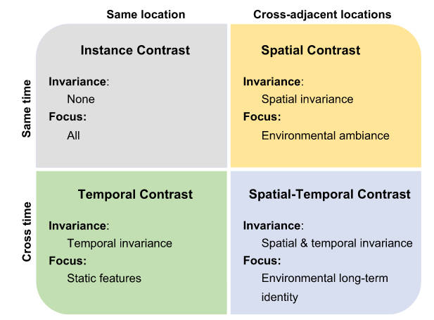
Learning street view representations based on a spatiotemporal contrastive learning framework
@article{li2026learning,title={Learning street view representations based on a spatiotemporal contrastive learning framework},author={Li, Yong and Huang, Yingjing and Zhang, Fan},year={2026},journal={Computers, Environment and Urban Systems},volume={125},pages={102393},issn={0198-9715},language={en},doi={10.1016/j.compenvurbsys.2025.102393},co_first={true},}
2025
IJHG
Street view images help to reveal the impact of noisy environments on the survival duration of stroke patients
Jing Xiao, Teng Fei, Bo Yu, Yingjing Huang, and Yunyan Du
@article{xiao2025street,title={Street view images help to reveal the impact of noisy environments on the survival duration of stroke patients},author={Xiao, Jing and Fei, Teng and Yu, Bo and Huang, Yingjing and Du, Yunyan},year={2025},journal={International Journal of Health Geographics},volume={24},number={1},pages={27},issn={1476-072X},doi={10.1186/s12942-025-00416-8},language={en},}
Annals of GIS
Representation learning for geospatial data
Yu Liu, Xuechen Wang, Yidan Wang, Fei Huang, Yingjing Huang, Yong Li, Weiyu Zhang, Shuhui Gong, Gengchen Mai, Yao Yao, Yang Yue, Haifeng Li, and Fan Zhang
@article{liu2025representation,title={Representation learning for geospatial data},author={Liu, Yu and Wang, Xuechen and Wang, Yidan and Huang, Fei and Huang, Yingjing and Li, Yong and Zhang, Weiyu and Gong, Shuhui and Mai, Gengchen and Yao, Yao and Yue, Yang and Li, Haifeng and Zhang, Fan},year={2025},journal={Annals of GIS},pages={1--27},publisher={Taylor \& Francis},issn={1947-5683, 1947-5691},doi={10.1080/19475683.2025.2552157},language={en},}
IJGI
Evaluating Urban Greenery Through the Front-Facing Street View Imagery: Insights from a Nanjing Case Study
Jin Zhu, Yingjing Huang, Ziyue Cao, Yue Zhang, Yuan Ding, and Jinglong Du
ISPRS International Journal of Geo-Information, 2025
@article{zhu2025evaluating,title={Evaluating Urban Greenery Through the Front-Facing Street View Imagery: Insights from a Nanjing Case Study},author={Zhu, Jin and Huang, Yingjing and Cao, Ziyue and Zhang, Yue and Ding, Yuan and Du, Jinglong},year={2025},journal={ISPRS International Journal of Geo-Information},volume={14},number={8},pages={287},publisher={Multidisciplinary Digital Publishing Institute},issn={2220-9964},doi={10.3390/ijgi14080287},language={en},}
Cities
Measuring urban physical environments using image deep features
@article{huang2025measuringa,title={Measuring urban physical environments using image deep features},author={Huang, Yingjing and Zhang, Fan and Wu, Lun and Liu, Yu},year={2025},journal={Cities},volume={166},pages={106196},issn={0264-2751},language={en},doi={10.1016/j.cities.2025.106196},}
GSIS WHU
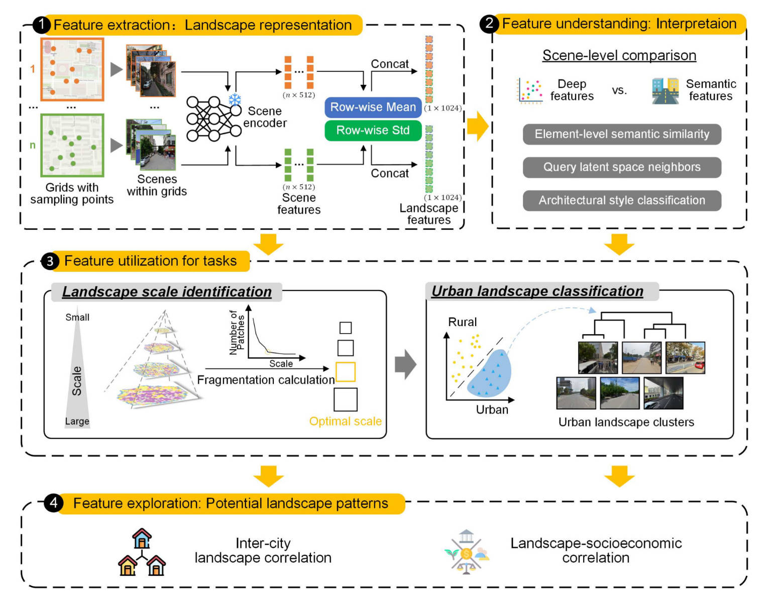
Intelligent Computational Representation of Urban Imagery
Yingjing Huang, Fan Zhang, Yong Li, Lun Wu, and Yu Liu
Geomatics and Information Science of Wuhan University, 2025
@article{huang2025cheng,title={Intelligent Computational Representation of Urban Imagery},author={Huang, Yingjing and Zhang, Fan and Li, Yong and Wu, Lun and Liu, Yu},year={2025},journal={Geomatics and Information Science of Wuhan University},volume={0},number={0},issn={1671-8860},language={cn},doi={10.13203/j.whugis20240472},}
B&E
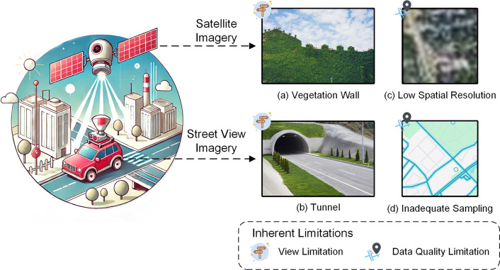
No “true” greenery: Deciphering the bias of satellite and street view imagery in urban greenery measurement
Yingjing Huang, Rohit Priyadarshi Sanatani, Chang Liu, Yuhao Kang, Fan Zhang, Yu Liu, Fabio Duarte, and Carlo Ratti
@article{huang2025no,title={No ``true'' greenery: Deciphering the bias of satellite and street view imagery in urban greenery measurement},author={Huang, Yingjing and Sanatani, Rohit Priyadarshi and Liu, Chang and Kang, Yuhao and Zhang, Fan and Liu, Yu and Duarte, Fabio and Ratti, Carlo},year={2025},journal={Building and Environment},volume={269},pages={112395},issn={03601323},doi={10.1016/j.buildenv.2024.112395},language={en},}
2023
CEUS
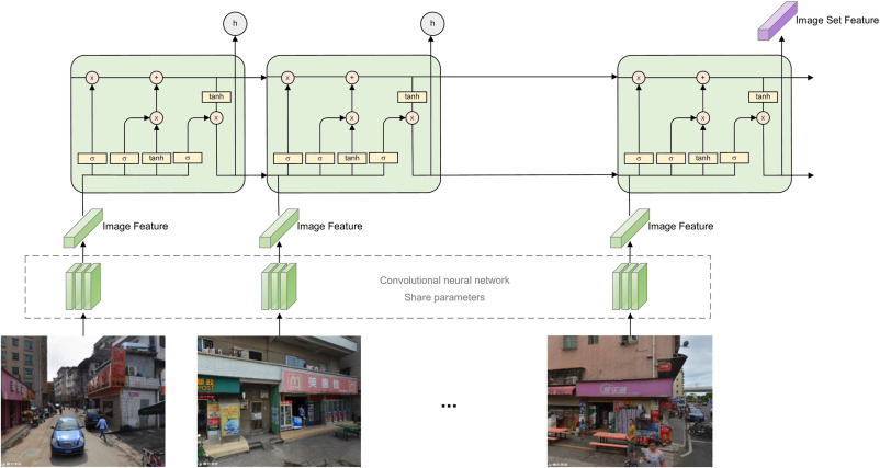
Comprehensive Urban Space Representation with Varying Numbers of Street-Level Images
Yingjing Huang, Fan Zhang, Yong Gao, Wei Tu, Fabio Duarte, Carlo Ratti, Diansheng Guo, and Yu Liu
Computers, Environment and Urban Systems, Dec 2023
@article{huang2023comprehensive,title={Comprehensive Urban Space Representation with Varying Numbers of Street-Level Images},author={Huang, Yingjing and Zhang, Fan and Gao, Yong and Tu, Wei and Duarte, Fabio and Ratti, Carlo and Guo, Diansheng and Liu, Yu},year={2023},month=dec,journal={Computers, Environment and Urban Systems},volume={106},pages={102043},issn={0198-9715},language={en},doi={10.1016/j.compenvurbsys.2023.102043},urldate={2023-10-12},}
2021
JGIS
Next-day Prediction of Pollen Concentration in Beijing by Integrating Remote Sensing Derived Leaf Area Index
Meng Bian, Shuyi Guo, Wei Wang, Yuhui Ouyang, Yingjing Huang, and Teng Fei
@article{bian2021Rong,title={Next-day Prediction of Pollen Concentration in Beijing by Integrating Remote Sensing Derived Leaf Area Index},author={Bian, Meng and Guo, Shuyi and Wang, Wei and Ouyang, Yuhui and Huang, Yingjing and Fei, Teng},year={2021},journal={Journal of Geo-Information Science},volume={23},number={1705},pages={1705--1713},language={cn},publisher={Journal of Geo-Information Science},}
IJGIS
Emotional Habitat: Mapping the Global Geographic Distribution of Human Emotion with Physical Environmental Factors Using a Species Distribution Model
Yizhuo Li, Teng Fei, Yingjing Huang, Jun Li, Xiang Li, Fan Zhang, Yuhao Kang, and Guofeng Wu
International Journal of Geographical Information Science, Feb 2021
@article{Li2021emotional,title={Emotional Habitat: Mapping the Global Geographic Distribution of Human Emotion with Physical Environmental Factors Using a Species Distribution Model},shorttitle={Emotional Habitat},author={Li, Yizhuo and Fei, Teng and Huang, Yingjing and Li, Jun and Li, Xiang and Zhang, Fan and Kang, Yuhao and Wu, Guofeng},year={2021},month=feb,journal={International Journal of Geographical Information Science},volume={35},number={2},pages={227--249},language={en},issn={1365-8816, 1362-3087},doi={10.1080/13658816.2020.1755040},urldate={2022-04-09},langid={english},}
2020
IJGI
GIS-Based Emotional Computing: A Review of Quantitative Approaches to Measure the Emotion Layer of Human–Environment Relationships
Yingjing Huang, Teng Fei, Mei-Po Kwan, Yuhao Kang, Jun Li, Yizhuo Li, Xiang Li, and Meng Bian
ISPRS International Journal of Geo-Information, Sep 2020
@article{Huang2020gis,title={{{GIS-Based Emotional Computing}}: {{A Review}} of {{Quantitative Approaches}} to {{Measure}} the {{Emotion Layer}} of {{Human}}--{{Environment Relationships}}},shorttitle={{{GIS-Based Emotional Computing}}},author={Huang, Yingjing and Fei, Teng and Kwan, Mei-Po and Kang, Yuhao and Li, Jun and Li, Yizhuo and Li, Xiang and Bian, Meng},year={2020},month=sep,journal={ISPRS International Journal of Geo-Information},volume={9},number={9},pages={551},issn={2220-9964},doi={10.3390/ijgi9090551},urldate={2022-04-09},language={en},}
Cities
Quantifying the Bias in Place Emotion Extracted from Photos on Social Networking Sites: A Case Study on a University Campus
@article{Huang2020quantifying,title={Quantifying the Bias in Place Emotion Extracted from Photos on Social Networking Sites: {{A}} Case Study on a University Campus},shorttitle={Quantifying the Bias in Place Emotion Extracted from Photos on Social Networking Sites},author={Huang, Yingjing and Li, Jun and Wu, Guofeng and Fei, Teng},year={2020},month=jul,journal={Cities},volume={102},pages={102719},issn={02642751},language={en},doi={10.1016/j.cities.2020.102719},urldate={2022-04-09},}
RS
Rapid Identification and Prediction of Cadmium-Lead Cross-Stress of Different Stress Levels in Rice Canopy Based on Visible and Near-Infrared Spectroscopy
Shuangyin Zhang, Jun Li, Siying Wang, Yingjing Huang, Yizhuo Li, Yiyun Chen, and Teng Fei
@article{zhang2020rapid,title={Rapid {{Identification}} and {{Prediction}} of {{Cadmium-Lead Cross-Stress}} of {{Different Stress Levels}} in {{Rice Canopy Based}} on {{Visible}} and {{Near-Infrared Spectroscopy}}},author={Zhang, Shuangyin and Li, Jun and Wang, Siying and Huang, Yingjing and Li, Yizhuo and Chen, Yiyun and Fei, Teng},year={2020},month=jan,journal={Remote Sensing},volume={12},number={3},pages={469},language={en},publisher={Multidisciplinary Digital Publishing Institute},issn={2072-4292},doi={10.3390/rs12030469},copyright={http://creativecommons.org/licenses/by/3.0/},langid={english},}
2017
TCSAE
Optimization Method of Calibration Dataset for VIS-NIR Spectral Inversion Model of Soil Organic Matter Content
Yiyun Chen, Tianci Qi, Yingjing Huang, Yuan Wan, Ruiying Zhao, Lin Qi, Chao Zhang, and Teng Fei
Transactions of the Chinese Society of Agricultural Engineering, Mar 2017
@article{chen2017optimization,title={Optimization Method of Calibration Dataset for {{VIS-NIR}} Spectral Inversion Model of Soil Organic Matter Content},author={Chen, Yiyun and Qi, Tianci and Huang, Yingjing and Wan, Yuan and Zhao, Ruiying and Qi, Lin and Zhang, Chao and Fei, Teng},year={2017},month=mar,language={cn},journal={Transactions of the Chinese Society of Agricultural Engineering},volume={33},number={6},pages={107--114},}
Patents
2025Granted
Method, Device, and Storage Medium for Comprehensive Landscape Representation Based on Street Imagery
Fan Zhang, Yingjing Huang, Yu Liu
China Patent ZL202510142438.1 · Granted December 16, 2025